Mwalimu-G
Elder Lister
@mzeiya here is some food for thought.
A May 2022 drone image of the submerged main entrance to Lake Nakuru National Park. Photo by James Wakibia/SOPA Images/LightRocket via Getty Images
Kenya’s Rift Valley lakes are rising, putting thousands at risk – we now know why
Published: January 16, 2023 3.45pm SAST
Author
The East African Rift Valley sits between the Afar Triangle in Ethiopia and Mozambique. Within it lie a series of freshwater and alkaline lakes organised like a string of pearls.
The Kenyan lakes in the Rift have witnessed significant water level increases. Recent increases in lake areas range from 21% for Lake Naivasha to 123% for Solai. Homes, schools and hospitals have been flooded. A Kenyan government report estimates that about 80,000 households – 400,000 people – have been affected by the floods since 2010. There are grave economic consequences, since agricultural fields and tourism infrastructure have been damaged.
To find out what is driving the rising lake levels, my colleagues and I carried out a detailed analysis for several most affected lakes using satellite remote sensing data. We studied the changes of the lake surface areas, lake levels and water volumes, as well as the factors driving the inflows and the water balance of the lakes. These are chiefly rainfall and evaporation. Our findings provide compelling evidence that increases in rainfall since 2010 explain the lake level rises.
Human activity and changes in underground permeability have been advanced before to explain the lake level rises. The results of our study illustrate that surprisingly minor changes in the water balance are enough to explain the lake level rises. An increase of only 0.4-2% of mean annual effective rainfall leads to the observed phenomena.
Our mission is to share knowledge and inform decisions.
About us
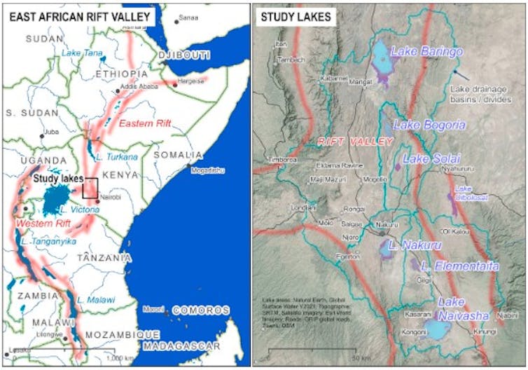
East African Rift Valley (left) and the study lakes in Kenya (right)
Key findings on Rift lakes
Three key findings/trends emerged from our data analysis:
The water area of Lake Solai, a smaller and less-known lake south of Lake Bogoria, increased from 3km² in 1984 to nearly 12km² in 2014 and 2020, a four-fold increase.
To put this into perspective, the water level rise of over 8 metres between the 1980s and 1990s for Lake Baringo and Lake Solai is equivalent to the height of around two storeys of a typical building.
In the period 2010-2020, mean annual rainfall increased by up to 30% for the Baringo, Bogoria and Solai catchments. In Nakuru (21%), Elementaita (25%) and Naivasha (25%), the rainfall increases were somewhat lower. After 2018, annual rainfall increased by even more than 50% compared to the long term averages.
Another factor driving the water balance is evapotranspiration. This is the amount of rainfall lost to the atmosphere. We found that this has also increased, though it’s not clear by how much, since no data on the ground exists to validate the findings coming from numerical simulations.
Independent of the uncertainties regarding evaporation, our results suggest that increases in rainfall most likely explain the lake level rises.
Dealing with the consequences
The regional climate in Eastern Africa has shown significant variability in the past, with long lasting periods of severe drought but also wetter periods as we are currently observing. Water level fluctuations in the Rift Valley lakes are not new. Lake Naivasha, for instance, was reduced to a puddle around 1850 and particularly low levels persisted throughout the 1940s and 1950s.

The virtually dried-up Lake Naivasha in the mid-1890s. Maasai pastoralists such as this duo could drive their cattle straight across the ‘lake’ at the time. Source: Nigel Pavitt, 2008: Kenya: A Country in the Making, 1880-1940.
What is new is the immediate risk posed by rising lake levels. Compared to the past, much higher population densities around the lakes put more people, their homes and their crops in danger.
So, will the lake levels keep rising?
We don’t know. Ten thousand years ago lake levels were significantly higher. South of Lake Turkana there was a lake called Suguta which was 300 metres deep, with a surface area of around 2,150km². This is over 10 times the size of current Lake Baringo. Lakes Bogoria and Baringo were connected and drained to the north towards Suguta, which abruptly disappeared around 8,500 years ago. (There are fears the lakes may connect again, leading to a cross-contamination of alkaline and fresh water.)
There is little that humans can do to intervene, especially regarding increases in rainfall and change in climate. What we can do is to alleviate the impact and be prepared as a society. We can aim at holding back water in the catchments and upstream areas. Afforestation, implementation of soil water conservation measures and enforcing infiltration of rainfall and surface runoff by technical and natural means are beneficial. Flood protection dams may be useful in some instances: this is however very costly.
Floods are natural phenomena, which were and will always be there. Preparedness is key in flood risk management. If Kenya and other countries affected by rising lake levels cannot change the situation, the only option is to learn to deal with it.
A May 2022 drone image of the submerged main entrance to Lake Nakuru National Park. Photo by James Wakibia/SOPA Images/LightRocket via Getty Images
Kenya’s Rift Valley lakes are rising, putting thousands at risk – we now know why
Published: January 16, 2023 3.45pm SAST
Author
 Mathew Herrnegger
Senior Scientist, Institute of Hydrology and Water Management, University of Natural Resources and Life Science (BOKU)
The East African Rift Valley sits between the Afar Triangle in Ethiopia and Mozambique. Within it lie a series of freshwater and alkaline lakes organised like a string of pearls.
The Kenyan lakes in the Rift have witnessed significant water level increases. Recent increases in lake areas range from 21% for Lake Naivasha to 123% for Solai. Homes, schools and hospitals have been flooded. A Kenyan government report estimates that about 80,000 households – 400,000 people – have been affected by the floods since 2010. There are grave economic consequences, since agricultural fields and tourism infrastructure have been damaged.
To find out what is driving the rising lake levels, my colleagues and I carried out a detailed analysis for several most affected lakes using satellite remote sensing data. We studied the changes of the lake surface areas, lake levels and water volumes, as well as the factors driving the inflows and the water balance of the lakes. These are chiefly rainfall and evaporation. Our findings provide compelling evidence that increases in rainfall since 2010 explain the lake level rises.
Human activity and changes in underground permeability have been advanced before to explain the lake level rises. The results of our study illustrate that surprisingly minor changes in the water balance are enough to explain the lake level rises. An increase of only 0.4-2% of mean annual effective rainfall leads to the observed phenomena.
Our mission is to share knowledge and inform decisions.
About us
East African Rift Valley (left) and the study lakes in Kenya (right)
Key findings on Rift lakes
Three key findings/trends emerged from our data analysis:
- Kenyan lakes showed low fluctuations and smaller water areas between 1984 and 2010, which have increased dramatically since 2010.
The water area of Lake Solai, a smaller and less-known lake south of Lake Bogoria, increased from 3km² in 1984 to nearly 12km² in 2014 and 2020, a four-fold increase.
- There have been dramatic fluctuations between minimum and maximum water levels.
To put this into perspective, the water level rise of over 8 metres between the 1980s and 1990s for Lake Baringo and Lake Solai is equivalent to the height of around two storeys of a typical building.
- Rainfall has strongly increased in the lake catchments since 2010.
In the period 2010-2020, mean annual rainfall increased by up to 30% for the Baringo, Bogoria and Solai catchments. In Nakuru (21%), Elementaita (25%) and Naivasha (25%), the rainfall increases were somewhat lower. After 2018, annual rainfall increased by even more than 50% compared to the long term averages.
Another factor driving the water balance is evapotranspiration. This is the amount of rainfall lost to the atmosphere. We found that this has also increased, though it’s not clear by how much, since no data on the ground exists to validate the findings coming from numerical simulations.
Independent of the uncertainties regarding evaporation, our results suggest that increases in rainfall most likely explain the lake level rises.
Dealing with the consequences
The regional climate in Eastern Africa has shown significant variability in the past, with long lasting periods of severe drought but also wetter periods as we are currently observing. Water level fluctuations in the Rift Valley lakes are not new. Lake Naivasha, for instance, was reduced to a puddle around 1850 and particularly low levels persisted throughout the 1940s and 1950s.
The virtually dried-up Lake Naivasha in the mid-1890s. Maasai pastoralists such as this duo could drive their cattle straight across the ‘lake’ at the time. Source: Nigel Pavitt, 2008: Kenya: A Country in the Making, 1880-1940.
What is new is the immediate risk posed by rising lake levels. Compared to the past, much higher population densities around the lakes put more people, their homes and their crops in danger.
So, will the lake levels keep rising?
We don’t know. Ten thousand years ago lake levels were significantly higher. South of Lake Turkana there was a lake called Suguta which was 300 metres deep, with a surface area of around 2,150km². This is over 10 times the size of current Lake Baringo. Lakes Bogoria and Baringo were connected and drained to the north towards Suguta, which abruptly disappeared around 8,500 years ago. (There are fears the lakes may connect again, leading to a cross-contamination of alkaline and fresh water.)
There is little that humans can do to intervene, especially regarding increases in rainfall and change in climate. What we can do is to alleviate the impact and be prepared as a society. We can aim at holding back water in the catchments and upstream areas. Afforestation, implementation of soil water conservation measures and enforcing infiltration of rainfall and surface runoff by technical and natural means are beneficial. Flood protection dams may be useful in some instances: this is however very costly.
Floods are natural phenomena, which were and will always be there. Preparedness is key in flood risk management. If Kenya and other countries affected by rising lake levels cannot change the situation, the only option is to learn to deal with it.