It's Me Scumbag
Elder Lister
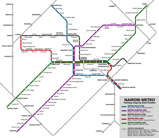
The Train Girl has gone and updated the fantasy rail map for Nairobi

Revised Nairobi Metro Fantasy Map
Buy this map on posters, shirts, and more:
https://www.redbubble.com/shop/ap/105122473
I definitely didn’t expect to have one of my maps go viral in Nairobi, but I’m very much grateful for Mbithi Masya’s showcase of my map! I’ve gotten a lot of feedback from Nairobians, and I’ve updated the map to account for it! I’ve also included a geographically accurate version.
EDIT 18 March 2022: I’ve gotten a ton more feedback, and I’m incredibly grateful to everyone who’s weighed in! This should be the final major change.
Next week Nairobians go be rocking this map on the tshirts...
Revised Nairobi Metro Fantasy Map
Buy this map on posters, shirts, and more:
https://www.redbubble.com/shop/ap/105122473
I definitely didn’t expect to have one of my maps go viral in Nairobi, but I’m very much grateful for Mbithi Masya’s showcase of my map! I’ve gotten a lot of feedback from Nairobians, and I’ve updated the map to account for it! I’ve also included a geographically accurate version.
- I’ve added several commuter rail routes to serve some of the smaller suburbs, and to connect the outer regions of the metro area to each other. Some routes are based on existing lines while others would be new.
- I’ve extended the Purple Line down Langata Rd, to serve Wilson Airport and continue to Rongai and Kiserian. I’ve also sent the northeastern end to Githurai rather than Mwiki, with Mihango and Ruai being served by the commuter rail.
- I’ve extended the Green Line to Karen and Ngong, and I’ve also rerouted it through Kibera since Langata Hospital would now be served by the Purple Line.
- I’ve extended the Blue Line from Ruaka to Banana Hill, where it would provide a transfer to the commuter rail.
- I’ve truncated the Red Line to Gitaru rather than Wangige, since Wangige would be served by the commuter rail.
- I’ve added several additional stations along the existing routes, and I’ve updated a few station names. I know they’re still not all accurate, though, so definitely let me know of any errors you spot!
EDIT 18 March 2022: I’ve gotten a ton more feedback, and I’m incredibly grateful to everyone who’s weighed in! This should be the final major change.
- I’ve extended the commuter rail to Central Station, stopping at Imara Daima and Likoni Rd. This would just be served by the route through Athi River, but it’d allow intercity trains from Mombasa to have direct access to Central Station!
- I’ve routed the Red Line through Kilimani, Kileleshwa, Lavington, and Kawangware—which was one of the most requested changes!
- I’ve routed the Green Line along Ngong Road rather than Langata Road. While this means part of Langata Road does lose service, it also means that the areas served by the previous routing of the Red Line get to still have service.
Next week Nairobians go be rocking this map on the tshirts...
